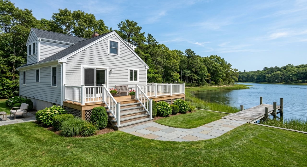
Dreaming of launching a kayak at sunrise or tying up your boat steps from your back door? In Mattituck, that waterfront lifestyle is real, but smart buyers know the details matter. Tidal depths, permits, flood maps, and habitat rules can shape what you can build, where you can berth, and what your insurance will cost. This guide shows you how to evaluate a Mattituck waterfront home with confidence, from boat access and docks to flood insurance and living shoreline options. Let’s dive in.
Why choose Mattituck waterfront
Mattituck Inlet is the Town of Southold’s primary north‑shore harbor of refuge with a mix of marinas, public ramps, a federal anchorage, private docks, and a town mooring field. The inlet’s long, narrow shape and variable depths support real boating access and a vibrant working‑recreational waterfront. According to the Town’s Harbor Management Plan, navigation, dredging, and channel maintenance are active topics, so you should match your boat to the waterway you plan to use. You can review the harbor’s uses and management focus in the Town of Southold’s Harbor Management Plan on the state site for Southold’s harbor management resources.
The practical takeaway is simple: Mattituck offers excellent access, but depth and channel width vary by location. If easy boating is a top priority, verify that the property’s dock, nearby creeks, or mooring field fit your vessel’s draft and beam.
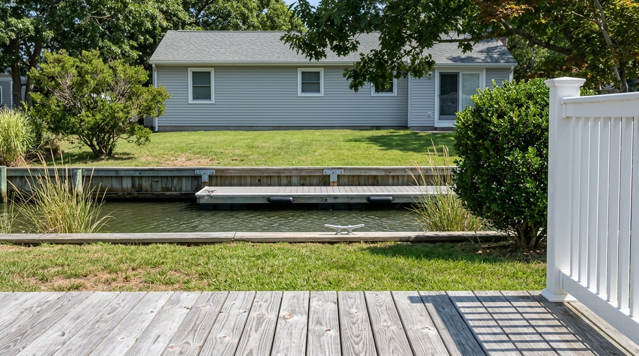
Boat access: depth, width, and shoaling
Depth at mean low water is the number you care about. Seasonal shoaling, narrow bends, and shifting sands can change what sizes of boats move comfortably. In some stretches near the head of the creek, depths can be shallow, while deeper pockets appear closer to the mouth. The Harbor Management Plan highlights the need to check recent conditions and dredging history for reliable navigation. You can learn more about channel conditions and navigation by reviewing Southold’s harbor management resources.
Here’s how to pressure‑test boat access before you buy:
- Speak with the Southold Harbor Master and nearby marinas about recent soundings, dredging schedules, and typical shoaling patterns.
- Confirm water depth at the dock at mean low water and ask for any available surveys or soundings.
- If you plan to moor, confirm mooring field rules, placement, and any waitlists.
- Consider how your boat’s draft and turning radius interact with the creek’s width and any channel bends near the property.
Permitting for docks and shoreline work
Waterfront improvements are heavily regulated. Most projects require local, state, and sometimes federal review. Plan for lead time and thorough documentation.
Town of Southold Trustees
The Town Board of Trustees regulates most in‑water and shoreline structures within its jurisdiction under Chapter 275. You typically need Trustee approval for docks, bulkheads, and similar work. Applications require surveys, soundings, prior permit history, and copies of other agency permits. The code sets dock placement standards, prohibited locations for new residential docks in certain creeks, approved materials, and public‑passage and address‑marking rules. Before you buy, pull the Trustee file for the property and confirm any conditions or violations. Review the Town’s standards in Southold’s wetlands and shoreline code.
NYSDEC coastal and tidal wetlands
New York State’s Department of Environmental Conservation issues permits for tidal wetlands and Coastal Erosion Hazard Areas. New or replacement bulkheads, groins, seawalls, dredging, and many dock projects require DEC authorization. In mapped erosion zones or significant habitats, certain activities may be limited or denied, and smaller seasonal floats may be treated differently. Expect the DEC to review wetland boundaries and potential impacts on eelgrass or shellfish beds. Learn what triggers review and typical requirements in the DEC’s Coastal Erosion Management Permit Program.
U.S. Army Corps of Engineers
If your project involves structures or fill in navigable waters, dredging, or work seaward of mean high water, the U.S. Army Corps of Engineers may need to authorize it under Section 10 or Section 404. New York uses a joint application to coordinate state and federal review, and some small residential docks may qualify under a Nationwide Permit. See the state’s joint permit application for coastal work.
Other local actors
You will likely coordinate with the Southold Harbor Master on mooring locations and navigation clearances, and with Suffolk County for septic and water quality issues. Some ramp and park access falls under the Mattituck Park District. The Town’s Harbor Management Plan and Trustee meeting agendas are valuable sources for up‑to‑date mooring field policies and permitted structures. Explore the Town’s program context through Southold’s harbor management resources.
Environmental constraints you should respect
Habitats and shellfish beds
Mattituck Inlet includes state‑designated Significant Coastal Fish and Wildlife Habitat, abundant shellfish grounds, and important tidal wetlands. Because of water‑quality sensitivity, both the Town and the DEC weigh eelgrass, shellfish, and habitat impacts when reviewing docks and shoreline work. Some areas have shellfishing closures or conditional openings. This is a key reason new residential docks are prohibited in certain locations. You can find context for habitat priorities in Southold’s harbor management resources.
Living shorelines vs hard armoring
Bulkheads and riprap are common on the North Fork, but regulators increasingly encourage living shorelines where they can provide equivalent erosion protection while improving habitat. Techniques can include marsh plantings, stone sills, or shellfish‑based features. Regional partners are piloting and promoting these approaches in the Peconic Estuary. For background and examples, see the Peconic Estuary Partnership’s overview of living shoreline initiatives and the DEC’s permitting guidance for coastal erosion management.
Flood zones, insurance, and building rules
Map your flood zone and base flood elevation
Your lender and insurer will rely on FEMA flood maps. Use the FEMA Flood Map Service Center to find your property’s Flood Insurance Rate Map panel, flood zone designation, and Base Flood Elevation. This is the baseline for the National Flood Insurance Program’s mandatory purchase requirement. Start with FEMA’s Flood Map Service Center.
Understand Risk Rating 2.0 and quotes
Since 2021, FEMA’s Risk Rating 2.0 has shifted NFIP pricing to a property‑specific model. Factors like foundation type, distance to water, elevation of the lowest floor relative to BFE, and replacement cost value now drive premiums. Two waterfront homes on the same street can have different rates. Ask for any existing Elevation Certificate early. If none exists, plan to commission one and request preliminary NFIP and private flood quotes. For how rating works, review FEMA’s Risk Rating 2.0 methodology summary.
Homeowners and wind or hurricane deductibles
Standard homeowners policies exclude flood, so you need separate flood insurance. For coastal Suffolk County, insurers commonly set percentage‑based windstorm or hurricane deductibles, often in the 1 to 5 percent range of dwelling coverage. These deductibles are meaningful out‑of‑pocket costs if a storm hits. The New York State Department of Financial Services explains the rules and disclosures for these deductibles. Read the DFS guidance on basic homeowners coverage and wind deductibles.
Renovations and substantial improvement
If you plan to remodel or expand, check whether your project will qualify as a substantial improvement under local and FEMA standards. Crossing that threshold can trigger requirements to elevate the structure to or above the current BFE, use pile foundations or breakaway walls in VE zones, and meet coastal construction standards. Build this into your budget and timeline.
Your Mattituck waterfront due diligence checklist
Use this buyer‑focused checklist to move from dream to done.
- Verify the flood zone and BFE on FEMA’s Flood Map Service Center. Request any existing Elevation Certificate and plan to obtain one if needed.
- Pull the Town of Southold Trustee file: docks, bulkheads, prior permits, and any open violations or conditions.
- Confirm the status and transferability of any dock, float, or mooring. Ask about town mooring rules and waitlists.
- Hire a marine contractor or surveyor to inspect docks, pilings, and bulkhead condition. Do not assume a marked dock is permitted or safe.
- Check depth at mean low water at the dock and along your travel route. Ask marinas and the Harbor Master about dredging history and any scheduled maintenance.
- Assess shoreline protection. If you need stabilization, discuss whether a living shoreline could meet your needs and how that would affect permits.
- Confirm septic system type, location, and distance from wetlands or the high tide line. Ask about any required or recommended upgrades.
- Get preliminary NFIP and private flood quotes using your Elevation Certificate and foundation details. Also obtain a homeowners quote that shows wind or hurricane deductibles.
- Ask your attorney to confirm riparian or littoral rights, easements, and any recorded rights to place structures or occupy the foreshore.
- Review local zoning setbacks and coastal erosion hazard maps to gauge what future projects may require.
- Contact local marinas and the Park District about seasonal slip availability, dry storage options, and ramp access rules.
A simple path to a confident purchase
- Clarify your priorities. Boat size, depth at the dock, and renovation plans should guide your short list.
- Gather the essentials. Flood map, Elevation Certificate, Trustee permit history, and a marine inspection set your baseline.
- Speak with local authorities. The Southold Harbor Master and Trustee office can confirm moorings, navigation, and permit records. Start with the Town’s harbor management resources.
- Price the risk. Get NFIP and homeowners quotes early, including any wind or hurricane deductibles.
- Align the offer. Use what you learn about permits, depths, and insurance to shape contingencies and timelines.
How we help North Fork waterfront buyers
You deserve clear, local guidance from first showing to final walkthrough. With deep roots on the North Fork and hands‑on deal management, we help you:
- Source and review Trustee, DEC, and USACE records so you know what is allowed today.
- Coordinate flood mapping, Elevation Certificates, and insurance quotes to avoid surprises.
- Connect with local Harbor and marina contacts for on‑the‑water perspective.
- Vet shoreline stabilization options and reputable marine contractors.
- Structure winning offers that reflect real water access and risk.
When you are ready to explore Mattituck’s waterfront, reach out for a tailored plan. You will get a calm, informed process designed around your lifestyle and boating goals. Connect with Cheryl & Regan to start your Mattituck search.
FAQs
Do I need a permit for a residential dock in Mattituck?
- Yes, most docks require Town of Southold Trustee approval and may also need NYSDEC and possibly USACE authorization depending on location and scope.
How do I check a Mattituck property’s flood zone and base flood elevation?
- Use FEMA’s Flood Map Service Center to pull the official map panel and BFE, and request or commission an Elevation Certificate to support insurance quotes.
What affects flood insurance pricing for Mattituck waterfront homes?
- Under FEMA’s Risk Rating 2.0, factors like foundation type, distance to water, lowest floor elevation relative to BFE, and replacement cost value drive premiums.
Can I replace a bulkhead or should I consider a living shoreline?
- DEC and local Trustees increasingly expect you to consider living shorelines where feasible, and they may limit hard armoring in sensitive habitats.
Who controls moorings and navigation in Mattituck Inlet?
- The Town, through the Harbor Master and Trustees, manages mooring policies and navigation; there is also a federal anchorage that shapes local use.
Are there habitat or shellfish restrictions that affect new docks?
- Yes, parts of Mattituck Inlet are significant habitat with eelgrass and shellfish beds, which can lead to limits or prohibitions on new residential docks.